(UPDATED Feb. 7: The SCRD has extended the state of local emergency, evacuation alert and evacuation order to Feb. 16.)
A state of local emergency was still in effect for Roberts Creek on Wednesday, with no plans to lift an evacuation order and evacuation alert that were issued Feb. 2 by the Sunshine Coast Regional District (SCRD).
“Right now with the rain predicted, I would say at this time we’re not in a position to rescind either the orders or the alerts,” SCRD chief administrative officer Dean McKinley told Coast Reporter.
Asked if the evacuation order and alert could be extended beyond the seven days they remain in force, McKinley said it’s possible. “We don’t know yet, but we’re going to be prepared for that eventuality,” he said.
The SCRD declared the state of local emergency after heavy rains that started Jan. 31 and continued into the next day washed out parts of the 1800 block of Lower Road. The washout exposed Fortis gas lines and the regional water main and detached a section of culvert, pushing it downstream.
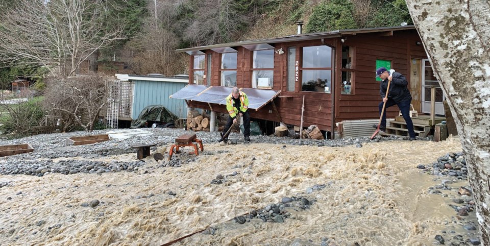
The risk from the debris flow caused by the flooding prompted an evacuation order for four properties “due to immediate danger to life safety” and an evacuation alert for another six properties.
The evacuation order is for 1815 Lower Road and 2016, 2022 and 2028 Ocean Beach Esplanade. McKinley noted that some of the property owners are not full-time residents and were not on their properties when the order went into force.
“I believe one person chose to stay, and it’s definitely not recommended, but that’s something that some people choose to do,” he said. “You can issue the order, but you can’t make people leave.”
The properties on evacuation alert are: 1994, 1998 and 2044 Ocean Beach Esplanade, 1843 and 1847 Lower Road and Lot 6, Plan VAP6446, District Lot 2497. Under an alert, residents are advised to be prepared to evacuate on 10 minutes’ notice.
McKinley said there has been some progress since the state of emergency was declared at 3 p.m. Sunday.
The exposed gas and water lines under Lower Road have been protected by a large I-beam and by topping about a dozen alders that were at risk of falling and hitting hydro lines and possibly the water and gas lines. As well, Fortis is rerouting one of its gas lines as a precautionary move.
“So that part was successful,” he said.
On Sunday, an excavator was used to dig a trench on the beach below Lower Road to divert water that was threatening cabins on Ocean Beach Esplanade. The machine was brought back on Monday to reopen the trench after more water and debris flowed into the area overnight.
Valerie Durant, who owns the property at 2028 Ocean Beach Esplanade, described the damage to the beach and two properties on either side of the overflowing channel as “carnage, to put it mildly.”
Before the excavator arrived Sunday, she said, water had filled half of the basement of one home, inundated her yard and spread under her house. Durant praised the Roberts Creek and Gibsons fire chiefs for their efforts to get the excavator to the site.
The Ministry of Transportation and Infrastructure area manager and an engineer were on site Monday, McKinley said.
“They’ve got to figure out what we’re dealing with so they can figure out what we need to do to get a more meaningful repair.”
Although officials flew over the site in a helicopter, McKinley said it was “hard to safely get in there to really see the extent of what’s happened.” He added that trees on top of some of the banks “are now in a precarious position, and a whole bunch of those are going to continue to come down. Some of them are pretty big.”
The SCRD on Wednesday was awaiting a hydrological report and was bringing in a drone to obtain quality images.
“The type of information we’re trying to get our heads wrapped around … is what has happened, what is still likely to happen and what can be done as a result of that information,” McKinley said. “We don’t know the answers to those questions yet.”
The west end of Roberts Creek was also affected by the heavy rainfall, which measured 130 mm at Port Mellon on Friday and Saturday, with a total of 199 mm between Jan. 29 and Feb. 1.
A washout Saturday reduced traffic on Beach Avenue at Camp Douglas to a single lane and closed the north section of Margaret Road. Both roads were reopened late Sunday afternoon after Capilano Highways crews made temporary repairs.
The 1800 block of Lower Road remains closed until further notice. All traffic, including transit buses, has been detoured to Joe Road.
Meanwhile, the province announced Feb. 4 that it would be making Disaster Financial Assistance (DFA) available for people in several regions affected by the flooding brought on by last weekend’s storm, including the SCRD and its municipalities.
DFA is available to eligible homeowners, residential tenants, small business owners, farmers, charitable organizations and local government bodies who were unable to obtain insurance to cover disaster-related losses.
Applications for DFA must be submitted to Emergency Management BC by April 4.
– With a file from Sean Eckford


