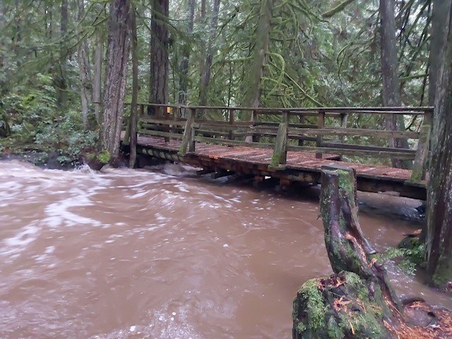
As rains pummel the Coast, the Sunshine Coast Regional District has closed Cliff Gilker Park due to high stream flows.
There is no estimated time on when the park will reopen, said SCRD manager of communications and engagement Aidan Buckley in an email. “The bridges will remain closed until parks staff have had an opportunity to do assessments after the stream level drops.”
As of Oct 17, B.C.’s River Forecast Center issued a High Streamflow Advisory throughout the Sunshine Coast and other areas of coastal B.C., where river levels are expected to rise rapidly. The provincial government has also advised residents to prepare for increased rainfall and possibility of flooding in Coastal areas, including the Sunshine Coast.
Environment and Climate Change Canada is forecasting strong winds and heavy rainfall, which began Tuesday. Rainfall warnings have been issued for the entirety of the Sunshine Coast, from Gibsons to Powell River.
Alyssa Charbonneau, Environment Canada meteorologist told Coast Reporter Wednesday that today is the wettest day the Coast will see this week and that the heavy rains are expected to taper off tonight.
Environment Canada is predicting that the Sunshine Coast will receive 50 to 80mm of rainfall over the next day, these heavy downpours may lead to flash floods and water pooling on roads.
Environment Canada’s Gower Point weather station in Gibsons recorded 71.4mm of rain in October, up to Oct. 17.
In its alert, Environment Canada said a pacific weather system will stall over the Coast Wednesday, bringing abundant moisture from the subtropics.
Charbonneau said that while showers are always a possibility this time of year, this weekend is expected to be drier and Environment Canada does not predict another atmospheric river for next week.
She included that predictions more than a week in advance this time of year do not have a “high degree of certainty.”
“We don't have the ability to see these storms coming more than a week in advance and even a week out, we might see the signal that somewhere along the coast might get heavy rain, but exactly where we end up seeing that heavy rain can change quite a bit," she said.
Charbonneau also mentioned that while the rain is expected to be lighter next week, the temperature is expected to drop.
“The beginning part of next week it cools off a few degrees, slightly below normal temperatures with highs of around 10 and overnight lows that could be closer to four. So a bit cooler than normal conditions."
Jordan Copp is the Coast Reporter’s civic and Indigenous affairs reporter. This reporting beat is made possible by the Local Journalism Initiative.


