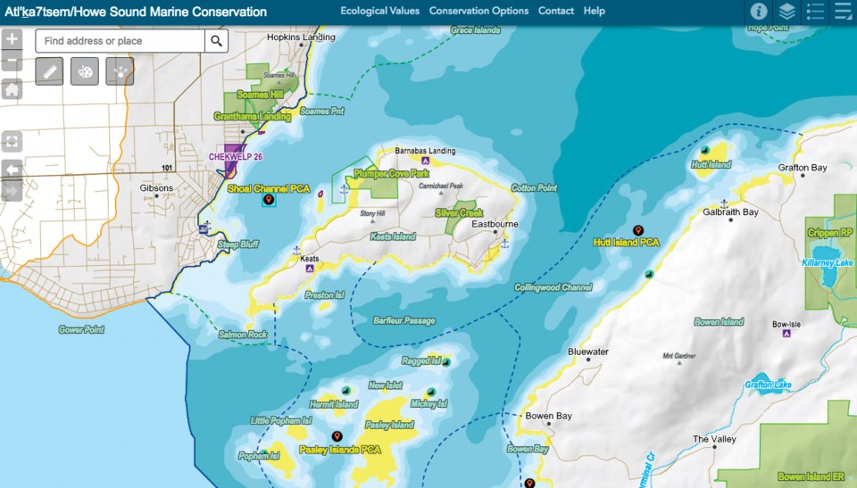
An online map that can display more than 140 “layers” of information about Howe Sound’s ecology is set to be revealed at a public event in Gibsons next week.
The Atl’kitsem/Howe Sound Conservation Map was created jointly through non-profits Ocean Wise and the David Suzuki Foundation and pulls information from conservation groups, government agencies and other sources to reveal habitats and ecosystems in the Howe Sound area.
Locations for glass sponge reefs, marine birds and mammals, eelgrass and other vegetation are included, as are spawning areas, reefs, estuaries and beaches. Scientists from DFO, the Vancouver Aquarium and the provincial government contributed information, as did local conservation groups such as the Future of Howe Sound Society and the Sunshine Coast Conservation Association. The team also worked with Sḵwxwú7mesh Nation.
It took approximately two years to ready the project for launch at a cost of $200,000, with funding from the two non-profits, donations and from grants, including from the Sitka Foundation and the Gordon and Betty Moore Foundation.
But the map isn’t complete. Instead, it’s a “living product,” according to Bill Wareham, project lead for the David Suzuki Foundation. As new science about Howe Sound emerges, it too can be added. “We’re inviting people to participate in continually adding to it,” Wareham said. “We’re trying to get people attached to it.”
At the launch, the organization is seeking input from local groups to add more information to the map and get feedback on its utility. The team will also be unveiling the map at events in Squamish and West Vancouver.
The idea to convey the information in an interactive map comes from the way Wareham saw people pore over and engage with paper maps. As an online and interactive tool, he said the abundant information would be easier to absorb, and to tell the whole story of the sound’s ecology.
“It allows the user to go in as deep as they want or just look at their favourite area, or their favourite type of wildlife,” Wareham said. The map is also intended to be used as an advocacy tool for groups seeking support for conservation initiatives.
“Along with our map, we have done an extensive analysis to show where habitat conditions are best suited to continue the sound’s ecological recovery [and] where development will need clear management,” said Fiona Beaty, a researcher with Ocean Wise, in a release.
Among the map’s supporters is MP Pamela Goldsmith Jones – and Wareham said they are hoping individuals and groups will use the map to help win federal funding for conservation initiatives in the area, such as through the $75-million Coastal Restoration Fund, which forms part of the federal Liberals’ Ocean Protection Plan.
“There’s streams of funding like that that are valuable to take advantage of to try and get some conservation work done,” he said. “There are some pretty big commitments.”
He also said industrial activity, such as the proposed LNG plant at Woodfibre, serve as examples for why a detailed map is needed as government and nonprofits consider conservation strategies for the region. “We need to plan it and manage it in a way that we don’t do what they did 50 or 60 years ago, which is destroy the environmental values,” Wareham said.
The Gibsons event will take place at 6:30 p.m. on March 5 at the Gibsons Public Market and is free.
The interactive map can be viewed at howesoundconservation.ca/mapapp


