
Think of it as a home inspection for the Howe Sound region.
The provincial government recently released cumulative effects assessments for our area as part of the Howe Sound Cumulative Effects Project.
The project looked at the region from the Strait of Georgia in the south, including Gibsons and West Howe Sound, to just before Whistler in the north.
The assessments provide information for First Nations and other levels of government to consider in their planning or decision-making.
Like a home inspection, the assessments provide an overview of the condition of the region, but not an evaluation of every inch of the "house."
The initial baseline assessments look at the condition of Roosevelt elk populations, marbled murrelet, grizzly bears, forest visual quality, and aquatic ecosystems.
The bottom line of the cumulative effects assessments is humans have impacted the environment. In particular, historic forest practices, industrial development, roads, and other development have made a difference to conditions.
"The main cumulative impacts are increases in road density and reductions of low elevation mature-to-old forests," reads a summary of the assessments. "The results also identified some positive trends such as the re-establishment of elk populations, improved forest visual quality and improving wildlife habitat through increasing mature-to-old forest recruitment."
"It is a version of cumulative effects and it is a starting point for more conversation," said Ruth Simons, executive director of the Future of Howe Sound Society, who The Chief reached in Ireland where she was attending a UNESCO conference.
According to Simons, the Future of Howe Sound Society had a role in spurring on the provincial government to create a project on Howe Sound.
"It is the first time that we have an overall look at what goes on in the region, instead of within the individual jurisdictions," she said, adding the information tells a story about the region.
"This information should be referred to in any community or other types of development plans... The government still has a ways to go before we can see it demonstrated that they are using it in the decision making."
One of the issues Simons sees with the data used for government Environmental Assessments of major projects is the timing.
"If we have a project, it is a long process... from the point in time you gather data, it can be another few years after you've collected data — and then decisions are made for the future, but now your data is out of date."
Simons questioned how, in an age when information moves so quickly, can the right decisions for the future be made, with the best data available?
"That is the part that bothers me about environmental assessments," she said.
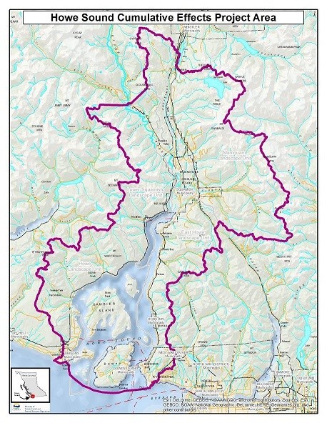
A map showing the area covered by the Howe Sound cumulative effects studies - Government of BC Image
Roosevelt elk
The bright spot of the Howe Sound assessments is the condition of the Roosevelt elk population.
By 1900, the animal was almost wiped due to human activity.
For the last 40 years, relocations and improved elk management by forestry, agriculture, and highway ministries have brought back the elk to our area, according to the assessment.
Approximately 1,600 Roosevelt elk were counted on the South Coast in 2014.
In the Howe Sound area, their populations are "increasing," or "stable to increasing." This means the elk in our region have either reached their population target or are still growing in numbers.
Roads, forestry and hunting remain a threat to the animal, however, so these issues should be taken into consideration, the report states.
Marbled Murrelet
The marbled murrelet, the small diving seabird found along the coastlines of the North Pacific Ocean, isn't faring so well in Howe Sound.
Almost 30 per cent of the world's total population of the bird, which is listed as threatened, exists in Canada.
Historical logging and development negatively affected the marbled murrelet's nesting habitat.
"Aerial surveys of Howe Sound indicate that there is actually a very limited amount of suitable marbled murrelet nesting habitat in the Howe Sound project area," reads the assessment.
Currently, nesting habitat is primarily available at higher elevations.
The provincial government's goal is to halt the decline and encourage the recovery of the bird by, among other things, increasing more of the birds nesting habitat.
Grizzly bear
An estimated 15,000 grizzly bears live in B.C.
In our area, bears are being displaced by people and limited by the food available for them.
In general, grizzly bear density is quite low in the project area with between 0 and 10 bears per 1,000 square kilometres. But there are 10 to 20 per square kilometre near the lower Squamish River.
They are expected to continue to be present in the lower Squamish, near the Squamish River and the Tantalus Range, and between the Squamish and Cheakamus rivers.
"This urban-wildland interface area has high levels of road density and human use near the Sea to Sky Corridor which can displace some bears from using quality habitats... on the eastern side of Sea to Sky Highway," the assessment states.
Aquatic ecosystems
The aquatic ecosystems assessments looked at the "ecological integrity of freshwater ecosystems" in the region.
The results varied, but there were some general takeaways.
"Roads appear to be a factor that should receive some further attention in terms of exploring precisely what amount of risk they pose and what management actions can be taken over time to reduce those risks," reads the report.
Logging has impacted the Mamquam watershed.
Industry has impacted waterways at the Woodfibre site, Squamish Terminals, and the Britannia Mine site.
Residential and commercial development at Britannia Beach, Squamish and Brackendale has also impacted area waterways.
Forest Visual Quality
Having swaths of forests on Crown land that are pleasing to look at — not drastically showing signs of human destruction — is a goal of the provincial government and the aim of its Visual Quality Objectives. "B.C.'s visual resource management program conducts a range of activities to maintain scenic quality expectations of the public and the tourism industry," the Howe Sound report states.
Assessments found that Howe Sound region forests look better than they did in 1995, based on a 2017 assessment.
"It appears that Forest Act tenure holders are, for the most part, meeting Visual Quality Objectives in the Howe Sound area," reads the assessment.
Two other assessments are not yet public.
The other two reports — old-growth and forest biodiversity — have not yet been published as they are currently undergoing some further review by provincial staff, according to Jeff Juthans of the Ministry of Forests, Lands, Natural Resource Operations and Rural Development. He added they will both be public when ready.


