A Gibsons-based professional photographer is creating bird’s-eye views of the Sunshine Coast that he hopes will become a profitable tool for local governments and businesses as well as a valuable resource for locals and tourists.
Greg Eymundson does commercial work, including virtual reality house tours for real estate companies, and conventional photography, but said he’s always been interested in exploring new technologies and was an early adopter of both 360-degree photography and using drones.
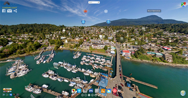
Eymundon’s taken those skills and created iPlanet360, an online portal that offers 360-degree aerial imagery of communities with embedded information links and maps to create a one-stop virtual tour.
He recently launched pages for Gibsons and the Sunshine Coast, but he said the idea for iPlanet360 grew from something he tried out while a tourist in the resort community of Yelapa, Mexico.
“Over the course of two or three years travelling there I mapped out the entire tourist experience and beyond. I went to the tops of mountains, flew the drone, linked it together and put every business in town on there,” Eymundson said. “That’s where this really started growing.”
Eymundson said the government of Mexico embraced the idea and gave permission to use official tourism logos and other resources and that convinced him the idea was worth pursuing here at home.
During slow times for his other commercial work, Eymundson started refining the technology and taking advantage of good weather days to get drone images of “key scenes” on the Sunshine Coast.
Now that it’s live online, the public can visit iPlanet360.com and see Gibsons, Roberts Creek, Sechelt and other areas like Dakota Ridge from the air in full 360-degree images and follow links to information about businesses, attractions and government services.
Eymundson jokes that some see the project as “a solution for a problem that doesn’t really exist,” but he sees a whole host of potential benefits for areas like the Sunshine Coast that are interested in attracting tourists, investors and new residents because “it gives a very real snapshot of what this area has to offer.”
“If I saw this footage of the Sunshine Coast before I came here, I’d be able to make more informed decisions about where I wanted to go and what I wanted to do, and because everything links to Facebook pages and websites it’s a valuable resource,” said Eymundson.
It is also, of course, a business venture and Eymundson said he’s approached local governments as well as the real estate industry about becoming involved as customers for the technology.
“Once people start seeing this, I fully believe it’s going to raise interest from other arenas,” he said.


