The public engagement period on Highway 101 Alternative Route Planning Study remains open until Aug. 31 and the Ministry of Transportation and Infrastructure (MOTI) reports it is seeing “high levels of participation."
As of Aug. 22, MOTI has received over 900 feedback form responses, along with other written submissions, a ministry spokesperson told Coast Reporter via email. Two public online public information and input sessions were hosted in June. The presentation material and a summary of the question and answer period from those events are available on the study webpage.
“We sincerely appreciate the time people are taking to share their views, and anyone who hasn’t yet participated is encouraged to complete the online feedback at www.gov.bc.ca/highway 101,” the email stated. The website dedicated to the project was recently updated.
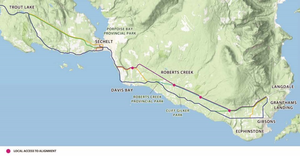
New routes for lower Coast areas
The purpose of the study is to develop a clear and supported long-term plan for the Highway 101 corridor between Gibsons and Sechelt. The study’s website acknowledges that traffic on Highway 101 has grown approximately 20 per cent in the last five years, primarily between those two communities. It states that while there is no foreseeable need for a full, end-to-end bypass route based on demand alone, key locations could benefit from an alternate route to address congestion, reliability and growing safety challenges.
During the online sessions, numerous Coast residents suggested that the proposed options would create new land use problems and that none of the alternatives would adequately address issues with the Coast’s primary vehicle traffic corridor.
Next steps
Following the public engagement period, ministry staff explained that they will be completing an analysis of the input received and preparing a report to summarize what was heard and how the input will be considered.
“Once that report has been shared with and reviewed by partners and key stakeholders (which include the shíshálh and Squamish First Nations) it will be posted to the project website. Due to the number of open-ended questions and the volume of input received, it’s expected that it could take several months before the report is ready to post. Concurrently, technical work will continue, which will include meetings with local government staff. Completion of the study is anticipated by spring 2023.
“The study partners, including the ministry, have agreed that based on work to date, all the options presented for public feedback are technically feasible. The next phase of the study will include an evaluation of the relative benefits and impacts of the shortlisted options – with a goal of identifying a preferred long-term vision for the corridor. This vision will support the ministry and local governments in making decisions about future land use and projects,” according to the ministry.
“With respect to next steps, it’s important to remember that this is a long-term study that is defining the corridor vision for next 30 years. There are no plans for any immediate acquisition or construction. Additional analysis and dialogue with local municipalities and communities would take place before moving ahead with any future projects that may arise as a result of this study,” the ministry’s email stated.


