Sunshine Coast residents now have until Aug. 31 to give feedback on the Highway 101 Alternate Route Study.
The province extended the feedback period past its previous July 28 deadline.
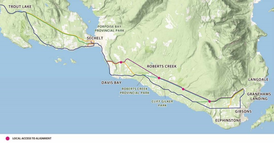
What's proposed?
Changes are being contemplated in four separate highway sections: Gibsons and area, Davis Bay from Largo Road to Chepli Avenue, entering and passing through downtown Sechelt, and SCRD West from Shorncliffe Avenue to Trout Lake. In each area, a number of different routing options and the potential for improvements within the existing highway right-of-way are explored.
At an information session on June 23, representatives of the Ministry of Transportation and Infrastructure (MOTI) and shíshálh Nation presented material and responded to questions entered into the online meeting format. They did not engage in conversations with any of the 38 members of the public who attended the meeting.
The 90-minute session focused on sharing information and seeking input to help short list options for potential highway improvements or bypass routings in areas between Gibsons and Trout Lake. The vision for the study is to develop a clear and supported long-term plan for that section of the highway corridor. The goal is to make recommendations for improvement projects to decision makers in late 2022 or early 2023.
What got asked?
Event moderator, Pam Ryan read and directed questions to the three MOTI staffers, two representatives of the shíshálh and spokesperson from consulting firm Binnie Civil Engineering that made up the presentation panel.
Some of the first questions posed focused on who was involved in the “pre-public” study consultation that had been undertaken. MOTI rep Gabriel Lord said that early discussions were held with community groups and agencies and that a listing of those is available on display boards posted on the website. It was also noted that no local land development companies were included in that process, but that everyone can be involved in the current opportunity to provide input.
Several questions came forward regarding the option of a four-lane highway through the Roberts Creek area, with individuals expressing concerns with the impacts of that on the environment, a local elk herd, the ambiance of the area and private land owners.
Two members of the public said they felt the study areas ignored addressing the route through Selma Park, which in their views, was an area of congestion and safety problems.
Lord explained the multiple account evaluation system that would be applied to each of the options to make a recommendation on the preferred route in each area. That involves reviewing customer service, environment, socio-community, economic development, reconciliation, and financial factors.
He was unable to tell an attendee the cost to date for the current study process, but stated he would respond to the person that asked that question at a later date.
The session was repeated June 29 and the ministry posted recordings of both events on the project website. The public can share comments online and a survey collecting route preferences and other suggestions will be open for submission of virtual or written input until Aug. 31.

