Results from an agricultural land use survey conducted in 2019 show there’s lots of potential for farming on the Sunshine Coast.
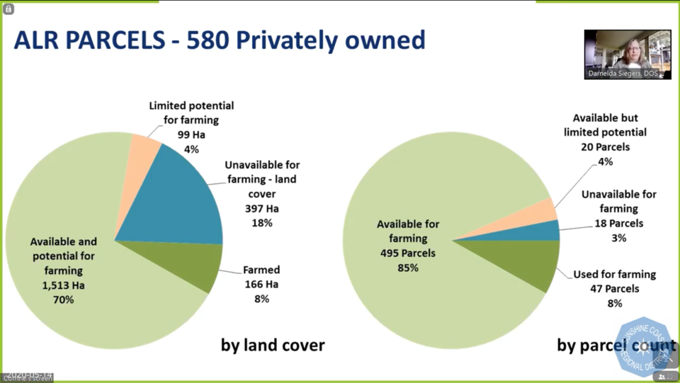
The survey found that of the 580 privately-owned Agricultural Land Reserve (ALR) parcels, only about eight per cent are farmed.
The study also found that 29 per cent of land with crops lies outside the ALR.
It’s the amount of land that could be farmed, but isn’t that’s most striking, according to Corrine Roesler, an agrologist with the B.C. Ministry of Agriculture who worked on the project and presented the findings to the Sunshine Coast Regional District (SCRD) planning committee on May 14.
“The bigger story here is what is available for farming. A full 70 per cent by land cover is still available for farming. It’s not being used. It doesn’t have a house on it, it doesn’t have a building on it, it doesn’t have a golf course on it. And that’s quite a significant amount of ALR that has potential,” Roesler said.
Water and the cost of land clearing isn’t part of the evaluation.
Of the crops that are in the ground, pasture is the most widespread, followed by forage, vegetables and tree fruit. The District of Sechelt has the most cropping, but only 11 per cent of its potential farmland is cropped.
There are 215 parcels with livestock on the Sunshine Coast, and Roberts Creek has the most. Most of the livestock on the Sunshine Coast is horses.
The study also found that “agricultural value added” is popular on the Sunshine Coast, with 33 parcels having on-site agri-tourism, direct sales or processing.
One crop that wasn’t included is cannabis.
Roberts Creek director Andreas Tize noted the reportedly $250-million Sunshine Coast industry was missing.
In response, Ministry of Agriculture engineer Stephanie Tam said they do not have “those data nailed down yet to calculate water demand and that’s why we’re reluctant adding that as a cropping category.” The inventory is meant to help establish water use needs.
There are approximately 4,000 hectares of ALR on the Sunshine Coast, of which about 67 per cent is divided into private parcels. The remaining is Crown and First Nations land. The study looked at the private parcels only.
Sechelt director Darnelda Siegers noted that “you couldn’t grow anything” on some of the ALR land, and asked if that was taken into consideration.
Roesler said they separate out land that is not suitable because of the topography – such as steep ravines or rocky outcrops and that some land is more suitable for non-soil-based agriculture, such as greenhouses. “We don’t want to say that the land has no potential. It may not have great soil potential, but it has farming potential.”
Once approved by the ministry’s security officer, the GIS data and a web application in development will be available to the public.
The ministry expects to update the data in five years.
Inventory used for water model
Also now available to local governments is an Agricultural Water Demand Model. The model uses the land use inventory and other data to determine future water needs for farms.
Based on a “worst-case scenario,” irrigation demand for farmland on the Sunshine Coast would rise by 67 per cent in 2053 compared with 2003 demand.
The model uses historical climate data from the 1960s to 2010 and other information to predict water needs for irrigated crops. It used 2003, the driest year on record in that data set, to calculate a “worst-case scenario” demand for 2053, which would see demand rise to 461,472 cubic metres, compared with 276,365 in 2003.
Climate change projections used in the model that look to 2100 put 2053 as the hottest and driest year.
Currently, 50 hectares of farmland are irrigated on the Sunshine Coast, out of a potential 604 hectares.
The model is intended to be used for planning water and land use.
More than two-dozen water demand models have been applied to approximately 24 regions in the province since 2006 to assess water needs for agriculture, using climate change projections.


