Three cutblocks located in the Gibsons aquifer recharge zone have been removed from a long-term planning map “to ensure clarity and remove ambiguity” about its five-year cutting plan, according to B.C.’s forests ministry.
The blocks, including one covering Chaster Creek tributaries, which supply the aquifer, appeared on a map in the province’s data catalogue described as representing “the most up to date spatial information,” published by BC Timber Sales (BCTS) through the Ministry of Forests, Lands, Natural Resource Operations and Rural Development (FLNRORD).
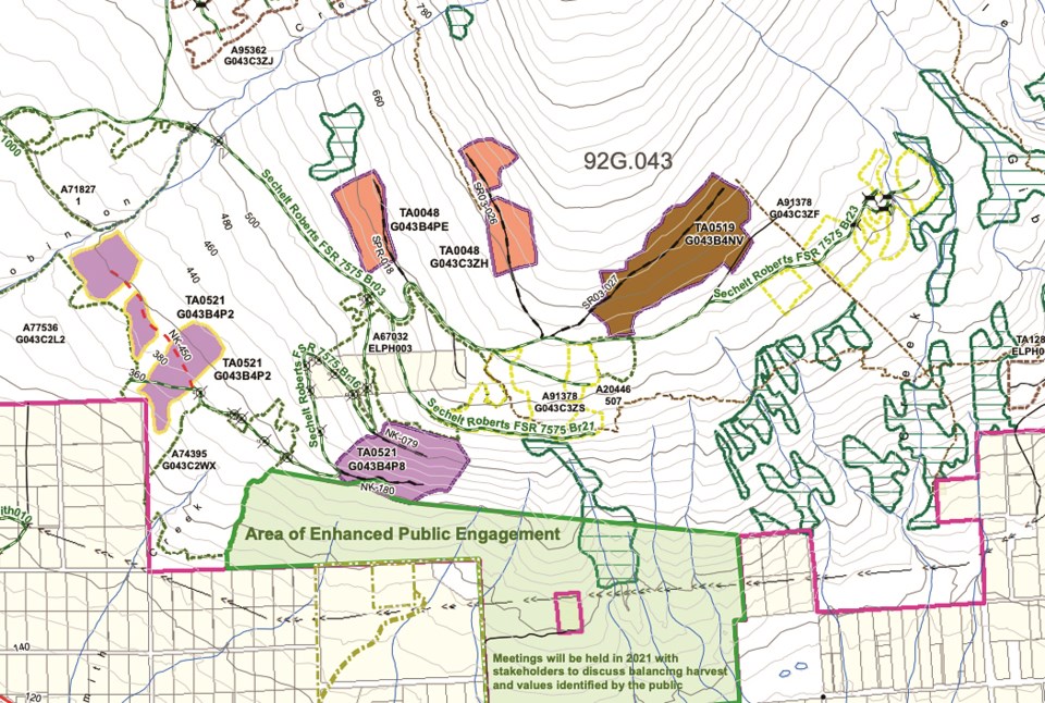
The map diverged from the most recent five-year operating plan map for the Sunshine Coast.
One block was situated south of Timber Sale Licence TA0519, scheduled for harvest in 2025, and covered two forks of Chaster Creek, as well as Webb Brook, which also feeds into Chaster.
TA0519, the largest cutblock of the cluster, is itself situated above Chaster headwaters.
Another block, east of TA0519, west of Sprockids Mountain Bike Park and north of Cemetery Road, was bounded by Chaster Creek and Gibsons Creek.
A third cutblock appeared directly east of Timber Sales Licence TA0521 and directly north of Reed Road Forest, also known as DL1313, and covered three tributaries that feed into Molyneux Creek.
The blocks, first identified by Elphinstone Logging Focus (ELF), are part of BCTS’s Multi-Year Development Plan map, said the ministry in an emailed statement to Coast Reporter, and “are not from the current published operating plan.”
The map includes “operating plan blocks and long-term planning shapes that may or may not be harvested in the future,” said the statement, and are included to support requirements in provincial regulations governing operating areas and stumpage information.
According to FLNRORD, “the openings on the Multi-Year Development Plan map should not be used for any other purpose beyond the intended support of BCTS regulations.”
The ministry said the blocks would be removed from the map, “to ensure clarity and remove ambiguity about which blocks are planned in the next five years.”
BCTS’s 2021 operating plan already contains six timber sale licences covering eight cutblocks where the aquifer recharges and surrounding areas on the slopes of Elphinstone overlooking the town. They are slated for harvest in two to four years.
FLNRORD said in its statement BCTS is currently seeking input from First Nations and stakeholders on the blocks it’s developing for operations to 2025.
Gibsons Mayor Bill Beamish told Coast Reporter in an email the town’s request to protect the watershed and aquifer recharge area “is still active and a priority for Gibsons council.”
“The Town continues to be concerned about any activities in our watershed-aquifer recharge area and will be commenting on the harvesting plan to the province,” he said.
The six timber sale licences in and around the Gibsons recharge zone total more than 78 hectares.
All three of the town’s water zones depend on the Gibsons aquifer for drinking water. According to an aquifer mapping study from 2013, the Mount Elphinstone block of the recharge zone potentially contributes about 55 per cent of the recharge to the aquifer, with Gibsons and Chaster creeks identified as the major watersheds in the study area.
“In theory, BCTS is removing future water to the aquifer,” said Elphinstone Logging Focus (ELF) organizer Ross Muirhead, who is urging FLNRORD and BCTS to remove the existing blocks from the recharge zone. “They’re removing future water volumes from the aquifer from stripping the land bare of its trees.”
In April 2020 when the initial cutblocks were introduced, SCRD directors asked that before BCTS harvests or engineers them and before it proposes new ones on Mount Elphinstone, that BCTS review the areas for impacts to groundwater resources.
The SCRD also requested as part of its communication protocol with BCTS that the experts who conduct a review be selected by local government water service providers.
They also invited FLNRORD, BCTS and other provincial bodies to collaborate on the development of a watershed governance model to protect the area’s drinking water supply.
Stormwater was also flagged in their response – with the objective of completing a stormwater management plan with the province for the Mount Elphinstone watershed scale.
Neither of those SCRD-led items have moved forward and according to SCRD’s planning general manager Ian Hall, “it has yet to be confirmed whether they will be included in the scope of the Regional Watershed Management Action Plan for which an RFP is currently being advertised.”
When the blocks were introduced last year, the SCRD raised concerns that TA0519 is located at the headwaters of Chaster Creek on a steep slope and above “known hazardous areas,” which “inherently adds risk and stormwater management responsibilities for downstream property owners, land managers and service providers.”
Elphinstone director Donna McMahon raised concerns over money spent by the province to fix damage to infrastructure caused by stormwater, as well as risks for property owners.
“Nobody at this time is responsible for damages to properties resulting from water diversion,” she said, “and the property owners are without any legal recourse.”
Those concerns were repeated in a letter from ELF directed to BCTS in February, which also cited concerns over impacts clearcutting TA0519, TA0521 and TA048 could have on the aquifer.
SCRD directors are expected to weigh in on the latest plan at a meeting this July. The district hasn’t received a response from BCTS regarding its request for a groundwater review by a third-party expert.
In a statement to Coast Reporter, FLNRORD said BCTS has commissioned and completed fieldwork for a hydrology report for south Elphinstone, and the report is expected to be completed by the end of June and distributed to the SCRD “and stakeholders.”
When asked whether BCTS plans to remove cutblocks from the aquifer recharge zone, FLNRORD said BCTS will follow the direction of the hydrology report, “which may include seeking advice from additional hydrologic professionals. Input from First Nations, the SCRD and other stakeholders will be considered as part of the timber harvest planning process.”


