Recommendations from the June 12 electoral services committee meeting were endorsed as proposed at the Sunshine Coast Regional District’s (SCRD) June 26 board meeting.
Foragers Meadery liquor licensing
The SCRD will recommend the province's Liquor and Cannabis Regulation Branch issue Lounge Area and Special Event Area endorsements for Foragers Meadery, located at 801 Leek Road in Roberts Creek.
The SCRD asked that conditions be attached to any provincial government approval, including that the proposed off-street parking provided for special events be designated as "temporary," that it not interfere with the agricultural productivity of the land, and that directional signage to the property’s parking areas be placed along Leek Road.
Another ask was for a prohibition on outdoor amplified music at the site.
The board requested that non-farm “special events” at the site be capped at 10 per calendar year, and that the combined person capacity of all liquor service areas during special events be limited to 120 patrons, as long as 27 off-street parking spaces are available.
The final ask was for a secondary emergency vehicle access from the orchard area to Leek Road.
Residential property development adjustments
A development variance permit was approved to facilitate construction of a proposed secondary suite at 3024 Green Way in Roberts Creek. The permit allows the property, zoned Residential Two (R2), to have parcel coverage up to 24.2 rather than15 per cent as provided for in the Zoning Bylaw.
There was also approval of a development variance permit to reduce the oceanfront setback from 15 metres to six meters, for the reconstruction of an aging deck at 8653 Redrooffs Road in Halfmoon Bay.
A waiver reducing the 10 per cent access road frontage requirement for one of three lots in a subdivision at Twin Creeks Road and Port Mellon Highway in the West Howe Sound area was granted. A similar waiver was granted for one of eight lots in a Pender Harbour/Egmont subdivision at 13685 Lee Road.
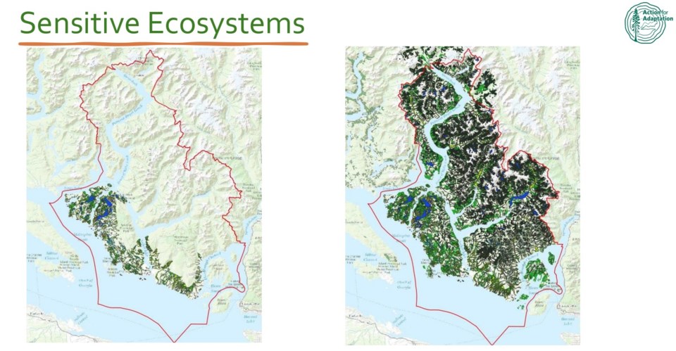
Protecting Coastal Douglas fir ecosystem areas
The board also heard from two delegations at its second meeting in June, both related to planning in areas contained in the Coastal Douglas fir moist maritime zone ecosystem.
As two members of the Halfmoon Bay Community Development Forum pointed out, the expanse from Secret Cove south to Sargeant Bay, is included in that zone. According to forum spokesperson Bill Henwood, that ecosystem is one of the “rarest” in the province, along with being one of the “most endangered” as 75 per cent of the province’s population lives in or near the zone, so there is pressure for continued land development for housing and community infrastructure.
The forum wants to help “protect and conserve” that unique forested area and is looking for opportunities to do so through the SCRD’s Official Community Plan (OCP) renewal process, the delegation told regional elected officials.
Following the presentation, the board asked staff about how to integrate that into the OCP update work. Director of planning, Ian Hall, noted that with the OCP renewal in the community engagement phase, staff can arrange a follow-up meeting with the forum. He also noted that other local and regional governments in the province have already been working in the area of protection of such resources through land use regulations and that the SCRD would be reaching out to discuss how that has been implemented.
The board also received delegation information from the Coastal Douglas Fir Conservation Partnership on its “Action for Adaption: Biodiversity Atlas and Policy Toolkit."
“The SCRD is home to many at-risk ecosystems,” Stephanie Woods of the partnership stated. She explained that her group was working on a seven-layered mapping of ecosystem areas, so that local governments have access to data from a variety of sources in an integrated view.
She noted the online map source is expected to be ready for use in early 2026 and that a toolkit to guide its use would be included online within six months of the release.
Elected officials had access to an early rendition of the work, and a map showing hydrologically sensitive areas was of particular interest to Elphinstone Area director Donna McMahon.
“It popped for me," she remarked, noting how the map showed the delineations between different watersheds.
She commented that “it’s my new favourite map” and said she was looking forward to the SCRD having access to an additional information tool.


