Is everyone else noticing the “Reed Road Bypass” is becoming more and more like navigating a video game? If there isn’t wild construction to detour you on a labyrinth-like alternative path, you’re caught bottoming out in a mysterious square-shaped piece of missing pavement, or dodging black bears and deer dashing across the road, past the cartoon-like wildflowers blooming. Then you arrive at the boss level.
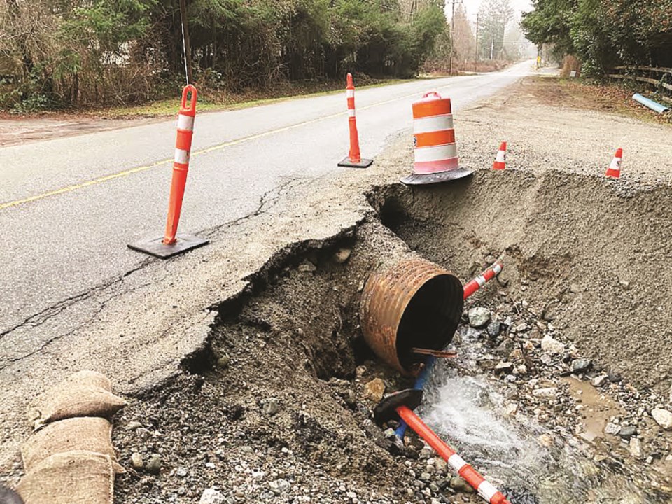
Not once, but twice now I have been driving home down Reed and had a logging truck veer towards my car at Payne. Those big logging trucks frequenting my street are the scariest, but with the ever-increasing traffic along Reed, this is now becoming an issue with standard sized cars too. You know the reason. We’ve all seen it. It’s been around since November. Those bright orange pylons frivolously decorating it, the same pylons creeping closer to the yellow line each day. The Hole of Payne Road. Where did it come from, is it actually getting bigger, and why hasn’t that thing been fixed yet?
The washout at Payne started last autumn when that atmospheric river ripped through B.C. causing us wild flooding like we had never seen. The heavy rain runoff in Area E caused a massive amount of debris to head down Mount Elphinstone and flood properties throughout Area E.
One creek overwhelmed by Elphinstone’s debris is named “Chaster Tributary” on most maps, which flows through the historic Bear Ranch property and, ironically, does not naturally connect to Chaster Creek at all. Bear Ranch is distinctive for the beautiful piece of wood curved around the property’s namesake in the driveway, and is home to Farmer Dan’s Family Farm. I have memories from when I was a kid of that piece of wood being dark and hinting at a bear-shape, perhaps why it got its name.
I spoke with the owner of the property, Chris Basil, who has been writing to different branches of the SCRD, the Ministry of Transportation and Infrastructure, Capilano Highways and other bodies of government who service the Sunshine Coast. He shared some of the correspondence with me and my initial thought was this is kind of ridiculous, but he does not want to point fingers; He wants solutions. Pretty reasonable considering throughout this beautiful, old piece of land there has been significant damage. Basil is concerned a car will make the one metre fall into the hole, or get into an accident.
“Traffic heading east must swerve across the centerline to pass the barriers”, Basil states, making Reed “effectively not a two lane road in front of my property and driveway”. There is a missing six metres lost off the shoulder of the road, extending right into his property. The larger pylons are constantly being knocked into the hole by traffic, vandals, or by the continuous erosion of the hole. Yup, it’s not your imagination, it is growing. Bear Ranch has spent a significant amount of money trying to secure the area, and Farmer Dan’s vegetable stand has suffered as well this season due to the gap in the road, going from six days a week last summer, to one day a week this summer. It’s a bit of a mess for the owner, the business, and anyone who happens to be passing by this whole situation.
Reasons range as to why it has not been fixed yet, for example, after the Church Well project is completed, or when the weather becomes drier. The creek has been dry for over a month, and I hate to state the obvious, but if we wait much longer it will get wet again. Here’s hoping some action is taken and we can get the road bumped up the priority list before the rains return and Reed can become a little more user-friendly.


