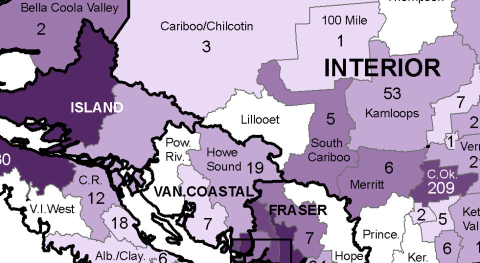
For the first time since she started giving regular reports on the COVID-19 pandemic, provincial health officer Dr. Bonnie Henry has released data on cases broken down by local health area.
At her Aug. 27 briefing, Henry displayed a map showing the data on cumulative cases from Jan. 1 to July 31, showing seven cases in the Sunshine Coast health area.
Until now, numbers have been released by health authority region or by health service delivery area, which for the Sunshine Coast meant local case counts were grouped in the North Shore/Coast Garibaldi area with North and West Vancouver, Squamish, the Sea to Sky corridor and Powell River.
“The map tells us that virtually every part of our province has been touched by COVID-19,” Henry said. “Communities, large and small, and geographically dispersed.
Adjacent to the Sunshine Coast, the Howe Sound local health area, which includes Squamish and Whistler, had 19 cases, West Vancouver had 44 and North Vancouver had 205. Powell River had zero. The local health area in the province with the most cases was Surrey, with 521.
The cases are mapped by the location of residence and cases with unknown residence or from out of province aren’t mapped.
According to Henry the mapped cases are the cases that were tested, or were epidemiologically linked to COVID-19.
“We know that there are additional people who were infected with COVID-19, particularly in the period of March and April, when we had limited testing and we knew that there were people coming from other places, for example, where they may have been exposed,” she said.
The BC Centre for Disease Control (BCCDC) also said the map does not include information on where the diagnosed patients were exposed to COVID and some may have contracted the disease working or travelling in other communities.
You can view the map, which Henry said will be updated monthly, at the BCCDC website: http://www.bccdc.ca/health-info/diseases-conditions/covid-19/data
– With files from Sophie Woodrooffe


