
Vancouverites won't get another major dumping of snowfall overnight, but they should brace for some freezing cold air.
Environment Canada has issued an Arctic outflow warning for the region as strong outflow winds make already frigid temperatures feel piercingly cold.
Starting on Tuesday (Dec. 20) night, temperatures will drop down to freezing -11 C, which will feel more like a biting -22 C with the windchill. Temperatures must feel below 20 C to meet the requirement for an Arctic outflow warning, according to Environment Canada meteorologist Jonathan Bau.
Temperatures are five to 10 degrees below seasonal normals, with some parts of the Lower Mainland expected to feel as cold as -30 C. And this bitterly cold system is expected to persist through the rest of the week until Thursday.
The frigid temps mean B.C. is likely to break a record set Monday night for power usage, according to BC Hydro, as people turn up the thermostat to try to keep warm.
No question: Snow will return to Metro Vancouver this week
While more snow is forecasted for the end of the week, the exact timing of the precipitation event is unclear, Bau tells Vancouver Is Awesome.
"This frontal system basically has been bashed up against this Arctic ridge," he explains. "Even though we haven't felt the effects, the Arctic ridge has been in place in the interior for five days.
"So it is not going anywhere...or at least it is going to put up a fight."
In other words, the cold air mass that was building in the interior started spilling into the Lower Mainland, bringing with it the bone-chilling windchill values. It will push up against the moist frontal system that will bring snow to the region later this week, making it more difficult to gauge when it will let up.
But a snow event will happen again this week.
"That isn't a question," clarifies Bau. "The latest possible time is early Friday morning and the earliest is Thursday night."
What that means, of course, is that travel will be impacted again this week. Friday morning commuters will face hazardous travel conditions, whether they plan to drive, ride the bus, or catch a flight.
The Arctic outflow will also keep temperatures well below freezing, meaning that the fresh snow event will pile on top of any that isn't cleared. That said, temperatures will be several degrees warmer on Friday.
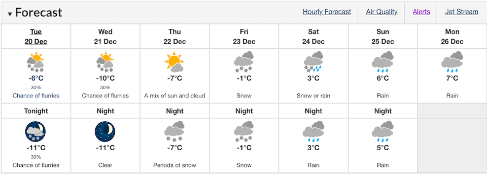
Metro Vancouver Weather Forecast
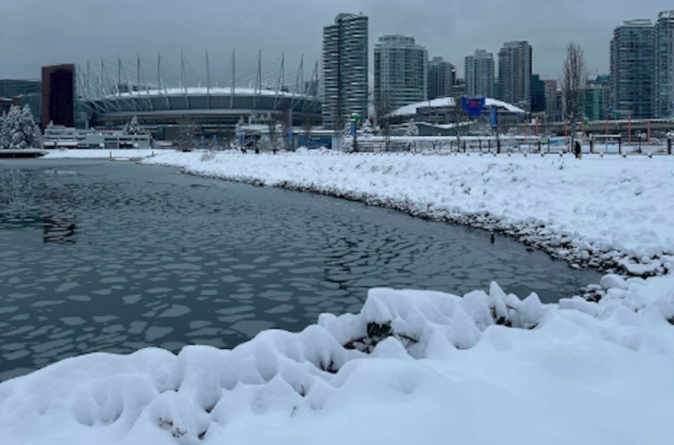
Metro Vancouverites woke up to several feet of snowfall Tuesday morning following the biggest winter storm of the year.
Downtown Vancouver received 30 cm of snowfall overnight, while other areas, such as Tsawwassen and South Surrey, received as much as 35 cm, according to Environment Canada's weather summaries.
Locals took to social media early Tuesday morning to share images of the fresh snowfall, showcasing accumulation amounts across the city and the greater Vancouver area.


