
With the construction of the Broadway Subway in full swing, it makes sense a new community plan for Broadway is being created.
A community plan is essentially a land-use plan to guide city planners; in the case of the Broadway Plan it stretches through three neighbourhoods, from Kitsilano to Mount Pleasant, along Broadway. It roughly encompasses the area between Vine Street on the west, Clark Drive on the east, 1st Avenue on the north and 16th Avenue on the south.
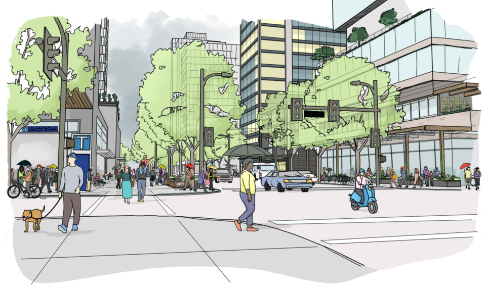
Broadway now
While past planners have created relatively consistent land-use and zoning situations, including smaller plans, the Broadway Plan will be a more cohesive and connected idea with a simple set of goals, the city says in a press release.
Those goals, according to the city are:
- greater affordability in housing and helping current tenants stay in the neighbourhood
- new and improved ways for people to move around
- improved parks and public spaces
- new and renewed public amenities
Currently, the area in the Broadway Plan is the location of 84,400 jobs, the second-largest job centre in the province after the city's core. Notably, Vancouver General Hospital is in the area, which means a good chunk of the jobs are in the medical field, and 44 per cent of the city's health care jobs are located in the area. However, the largest industry in the area is sales and service, followed by business, financial and administrative jobs.
It's also home to more than 78,000 people. A quarter of the city's purpose-built rental housing is in the area, and 42 per cent of the housing units inside the area are rental housing, many of them in walk-up apartments standing three or four stories. This creates one of the densest residential regions of the city, but one that lacks a significant number of children compared to other areas.
About 14 per cent of those living in the area work there as well, while another 62,500 commute in, as of the 2016 census.
The draft plan is in its fourth phase, which means it's the final draft before going before council for discussion and adoption.
Takeaway 1: Booming growth
The plan estimates and accommodates significant growth in the area in both population and jobs over 30 years. Up to 50,000 new residents and 30,000 new homes are to be expected, with 42,000 new jobs. In each case, that's around 50 per cent growth.
Affordability will play a role in that growth as well; in their housing policy booklet they note that the area has a lot of the city's "naturally occurring" affordable housing due to aging buildings being cheaper to rent. To help create more affordable housing the draft has policy suggestions around new developments having a percentage of units kept as below-market housing, with rents not more than 20 per cent below the average in the city as according to the Canada Mortgage and Housing Corporation. A report on the drafts housing policies notes it's the responsibility of senior governments to help with funding these policies.
Some of that will fall in line with the recent policy changes that require more family units built in multi-family developments.
Takeaway 2: New towers
To accommodate growth in an area already filled with buildings means taller buildings. The plan calls for a lot of height increases of buildings in the area, except in areas where it would affect the view from Queen Elizabeth Park.
The tallest buildings will be allowed around the new subway stations with heights between 30 and 40 storeys. In the shoulder areas (mostly areas along major roads but not around stations) towers between 20 and 30 storeys are expected. All this will likely create a second skyline for the city.
In some residential areas south of Broadway smaller high-rise apartment buildings up to 18 storeys will be allowed, with some rules attached to allow below-market housing. These would increase the density in neighbourhoods dominated by walk-up apartments.
One area the policy specifically cites is the Kingsgate Mall property, which would be zoned for a tower up to 30 storeys.
Takeaway 3: Mount Pleasant light industrial land
The city's core neighbourhoods don't have a lot of light industrial land, and some attention was given to the Mount Pleasant industrial area between Main and Cambie to the east and west and Broadway and 2nd Avenue to the north and south.
The plan lists a key direction in the neighbourhood as "strengthening the Mount Pleasant Industrial Area as a vibrant creative and cultural production hub by enhancing its light industrial function and supporting the innovation economy."
From a policy point of view, this means at least a third of the floor space in developments will have to be for light industrial uses like traditional production, distribution and repair industries.
Takeaway 4: Broadway a Great Street
One transformation that will change the character of a big swath of land would be turning a 4 km stretch of Broadway into a 'Great Street.' That would see the major thouroughfare for vehicle traffic become more pedestrian-friendly.
That would mean lanes reduced and bike routes, greenways and pedestrian space increased.
"To become a Great Street that is memorable and recognizable, and where people enjoy spending time on, Broadway needs to be an attractive and comfortable place for people to walk/roll and to gather," states part of the transportation draft.
Takeaway 5: Growth of a Creative District
The city calls the area along Great Northern Way between Main and Clark the creative district, in tune with Emily Carr University which is already based there.
The draft describes the goals as a "24-hour community with a strong focus on education, innovation, arts and culture." The policy suggestions call for the development of artist live-in spaces, room for digital entertainment companies and creative product manufacturing, but also allow for hotels, tech companies and laboratories.
Takeaway 6: Way more greenways
A number of greenways are suggested in the public real framework, including along 14th Avenue, 7th Avenue in Fairview and 10th in Mount Pleasant. North-south routes along Ontario, Heather, Alder and Pine street are all suggested as well, along with others.
"These car-lite to car-free corridors connect to key destinations and enhance natural systems and public life," the transportation draft says.
They would have a park-like feel with wide paths and minimal vehicle interactions.
Takeaway 7: $1.2 billion in public benefits
A high-level 10-year public benefits strategy lists a few ideas that could follow but will cost around $1.2 billion. That includes $100 million for the aforementioned Great Street of Broadway.
More significantly $450 million would go towards up to 850 units of social housing units and $300 million for upgraded water systems in the area including sewer lines and drainage, along with new rainwater infrastructure.
To see the whole draft and provide feedback, the city has a whole bunch of information on its website.


