The 10th annual BC Bike Race is coming through Sechelt this weekend. Riders leave Earls Cove on Saturday, July 9 and make their way down the Sunshine Coast, finishing in Langdale on Sunday before they head across Howe Sound to North Vancouver, Squamish and finally Whistler.
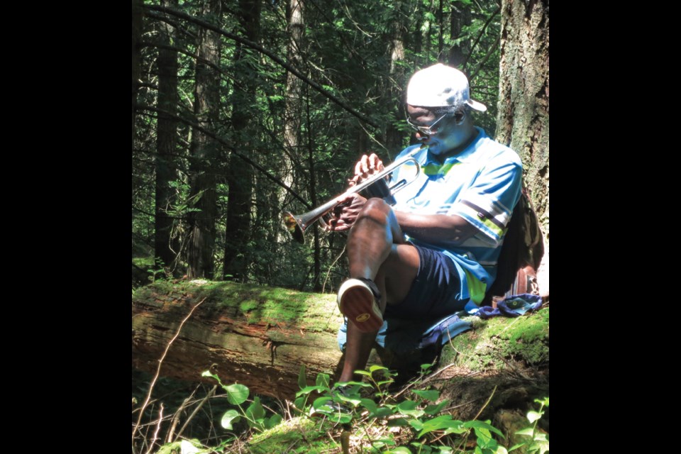
There are 14 spectator-viewing locations between Saltery Bay and Langdale, which have been marked on maps. Sunshine Coast course director Rod Camposano recommends checking out the Big Firs picnic area on Saturday, which is just below where Randeesh Goff will be serenading riders with trumpet music.
“It’s an uphill portion, so riders will be able to slow down and listen before they head towards the finish,” Camposano said. “He plays for the entire time the riders are going through. It’s amazing.”
“People really appreciate me playing for them because I go up to the top of the mountain,” Goff said. “The spot where they see me is when they are about to go back down. They’re all happy that I’m out there, so I like to do it for them.”
The courses are all marked with pink three-inch-wide tape that says BC Bike Race on it.
“The closer the [riders] get to Sechelt, the wider the spread,” Camposano said. “You have the lead riders [who] average 20 km an hour – so they take about three hours to get from Earls Cove to the finish line. They move fast and everybody else is a little bit slower, so the race gets spread out. The last people will be coming in at 6 at night, and the lead guys will be coming in at 2 p.m.”
Big Firs is nine kilometres north of Sechelt on Highway 101, and 400 m before Trout Lake. Take the Halfmoon-Carlson Forest Service Road, which leaves the highway at a small rock quarry on the right. Proceed 2.8 km on the main logging road, ignoring spurs to the left and right. Park at a wide spot immediately beyond the trail. Walk down the road until you see the pink tape.
BC Bike Race viewing locations
There are 14 places from Saltery Bay ferry terminal to Langdale where can you go to view the BC Bike Race on July 9 and 10 on the Sunshine Coast.
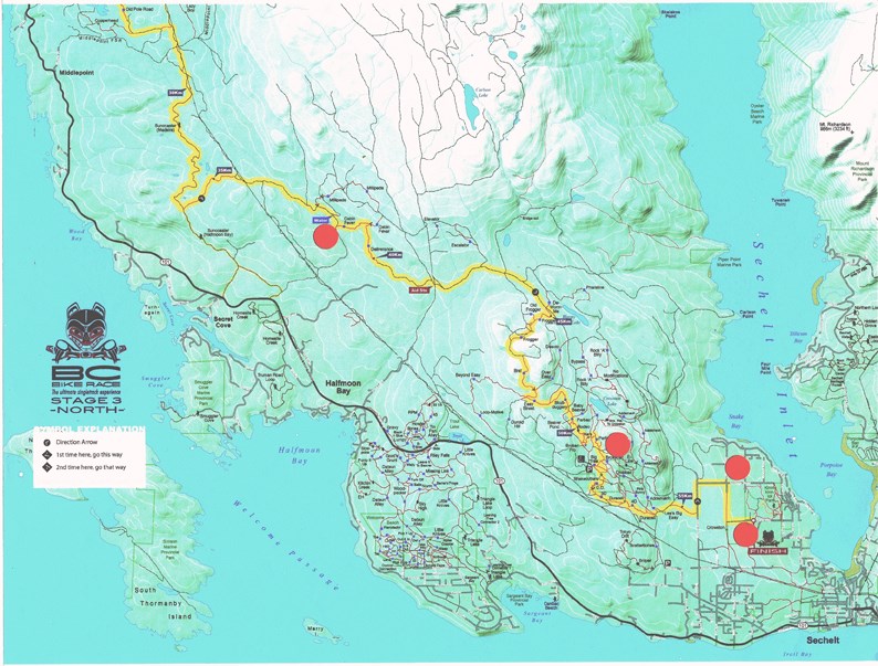
Saturday, July 9, Day 3
11 a.m. - Leaving the Earls Cove ferry terminal (if the race is on time).
11:05 a.m. - Earls Cove where Egmont Road meets Highway 101.
11:30 a.m. - Salt sheds on Highway 101, 14 minutes or 14.5 km north of Madeira Park, across from Sakinaw Lake Road, where the power lines are close to the highway.
12 p.m. - Menacher Road turnoff, 3.4 km or four minutes north of Madeira Park just south of Gunboat Bay. Continue past MacNeill Lake Forest Service Road on the left on to Menacher Forest Service Road fork in the road and the aid station (Scary Hill bypass and bottom end of Cougars).
1 p.m. - Homesite Creek Road turnoff from Highway 101 (2.9 km or six minutes) stay to the right (bottom of Cabin Fever).
1:45 p.m. - Big Firs picnic table, nine km north of Sechelt on Highway 101, and 400 m before Trout Lake, take the Halfmoon-Carlson Forest Service Road that leaves the highway at a small rock quarry on your right. Proceed exactly 2.8 km on the main logging road, ignoring spurs to the left and right. Park at a wide spot immediately beyond the trail. Continue down the road for about 10 minutes until you see pink tape.
2 p.m. - Crowston Road and Heritage Road (10 minutes and 7.2 km) via Highway 101 and Mason Road, West Sechelt. From Sechelt going north, follow Highway 101 for 2.2 km. Turn right onto Norwest Bay Road for 1.7 km. Turn right onto Mason Road for 2.6 km. Turn right onto Heritage Road for 650 m to Heritage Road and Crowston Road.
2:15 p.m. - Top of Ripple Way at the race day’s finish at Kinnikinnick Park and tent village. From Highway 101 and Trail Avenue in Sechelt, six min (3.7 km). Head north on Trail Avenue toward Cowrie Street for 1.8 km. Trail Avenue turns right and becomes Reef Road (650 m). Reef Road turns left and becomes Shoal Way (270 m). Continue straight to stay on Shoal Way (130 m). Turn right onto Lighthouse Avenue (400 m). Continue straight onto Ripple Way (500 m) in Sechelt.
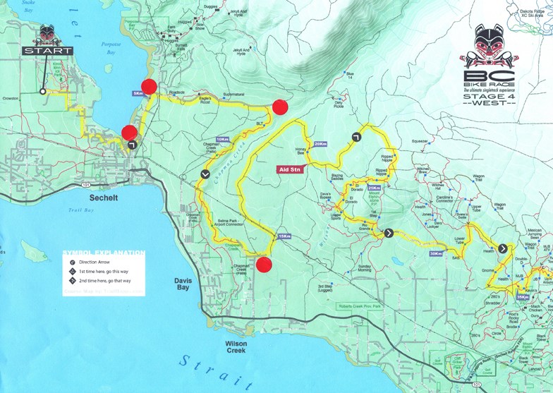
Sunday, July 10, Day 4
8:30 a.m. - Race starts at Kinnikinnick Fields (see 2:15 directions on Saturday, July 9).
8:35 a.m. - East Porpoise Bay Road (across from Ebbtide) at Wharf.
8:45 a.m. - Dusty Road. Turn off Wharf onto East Porpoise Bay Road that turns into Sechelt Inlet Road in three minutes (1.7 km) to Dusty Road
8:50 a.m. - Turn right onto Dusty Road for three minutes past the Sechelt Landfill to the end of Dusty Road.
9 a.m. - Top of Field Road. Turn on to Field Road in Wilson Creek, three minutes (2.3 km) to the end of Field Road.
9:30 a.m. - Up B& K Logging Road (by Cliff Gilker Park in Roberts Creek). Drive for 3.5 km up B&K (also called Largo Road).
10 a.m. - Sprockids Park entrance, 2.3 km up the hill from the ferry terminal, turn on to Stewart Road for one minute (260 m).
10:20 a.m. - Langdale Ferry Terminal.
Countries and number of riders from a country:
Canada 208
United States 185
Australia 27
Mexico 26
Peru 24
United Kingdom 22
Switzerland 17
Germany 16
Norway 15
Brazil 11
New Zealand 9
South Africa 9
Singapore 7
Denmark 6
Colombia 5
Hong Kong 5
Guatemala 4
Puerto Rico 4
Ireland 4
Austria 3
Netherlands 3
Spain 3
Venezuela 2
Belgium 2
France 2
Guadeloupe 2
Italy 2
Martinique 2
New Caledonia 2
Qatar 2
Sweden 2
United Arab Emirates 2
Argentina 1
Japan 1
China 1
Liechtenstein 1


